Hurricane Irma made landfall in the Caribbean Wednesday as a Category 5 storm.
With sustained winds near 185 mph, the powerful storm moves toward the eastern coast of the U.S.
As Florida braces for the hurricane to make landfall, striking images from the storm are making the rounds on social media.
Here are just a few of the images and videos being posted online.
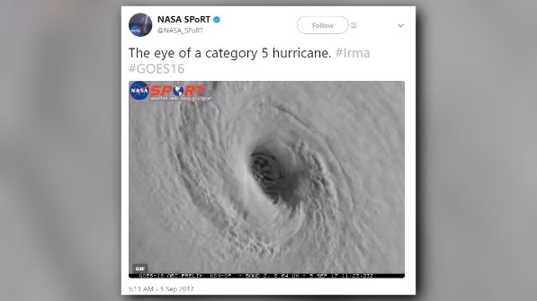
The NASA SPoRT Twitter account is tweeting some stunning images of the Eye.
The eye of a category 5 hurricane. #Irma #GOES16 pic.twitter.com/eATVZspJZx
— NASA SPoRT (@NASA_SPoRT) September 5, 2017
Seeing the view from NOAA satellites also shows the scope of how big the storm is.
Watch as Hurricane #Irma moves toward the Leeward Islands in this #GOES16 geocolor loop. Get the latest on Irma @ https://t.co/cSGOfrM0lG pic.twitter.com/ixIhkXqVNa
— NOAA Satellites (@NOAASatellites) September 5, 2017
Watching the gravity wave pattern in this tweet is mesmerizing.
The gravity wave pattern emanating outward is astounding. Like someone dropping rocks into a pond. Hurricane #Irma #GOES16 pic.twitter.com/k4CphT0Wfz
— NASA SPoRT (@NASA_SPoRT) September 5, 2017
Astronauts even got a front-row seat as the International Space Station flew over the storm.
The International Space Station’s external cameras captured a dramatic view of Hurricane Irma as it moved across the Atlantic Ocean Sept. 5. pic.twitter.com/mc61pt2G8O
— Intl. Space Station (@Space_Station) September 5, 2017
Residents in Florida are already preparing for Irma and bracing for the possible severe weather. The storm is expected to make its way near Florida this weekend.
PHOTOS: Hurricane Irma preparations