ST. LOUIS — Tropical Storm Beryl has been making headlines for a while now. It was one of the earliest, strongest storms on record as it developed in June.
Beryl made landfall in Texas as a Category 1 hurricane early Monday morning. Now, the remnants are in the St. Louis region.
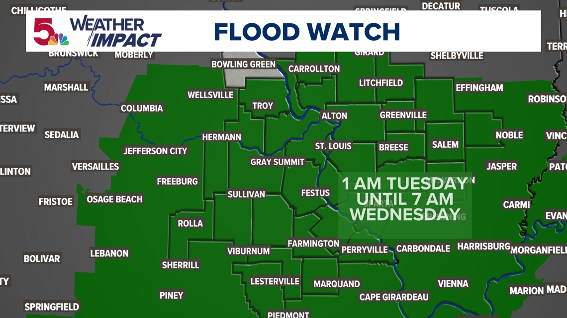
The entire St. Louis region continues in a flood watch through part of tonight. Numerous areas in the region have since been put under flood alerts, including:
- A flood advisory issued for St. Louis City, St. Louis County, and St. Charles County in Missouri and St. Clair, Madison, Monroe, Calhoun and Bond counties in Illinois until 6 p.m. Tuesday.
- A flood advisory issued for St. Louis, Jefferson, Franklin, St. Francois, Crawford, Iron, and Washington counties until 5 p.m. Tuesday.
A tornado watch is in effect for southern portions of Illinois, Indiana, Kentucky and Tennessee. It includes Jefferson county Illinois (Mt. Vernon area) and points south.
Click here for the full Weather Impact forecast.
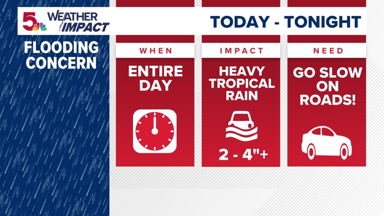
How much rain will Beryl bring?
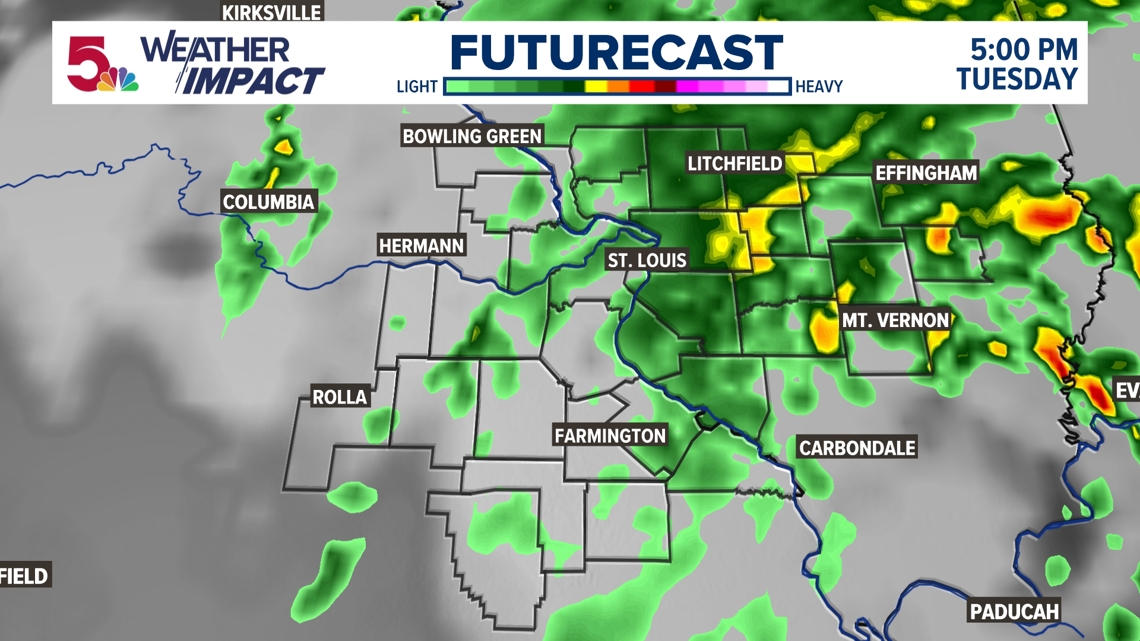
The system will bring cloud cover, rain and isolated thunderstorms. Tuesday will be the coolest, cloudiest and rainiest day the area will see as a result of the remnants of this tropical system. Moderate to heavy rain continues around the St. Louis metro, south and westward.

A flood watch continues until 7 a.m. Wednesday for most of the area.
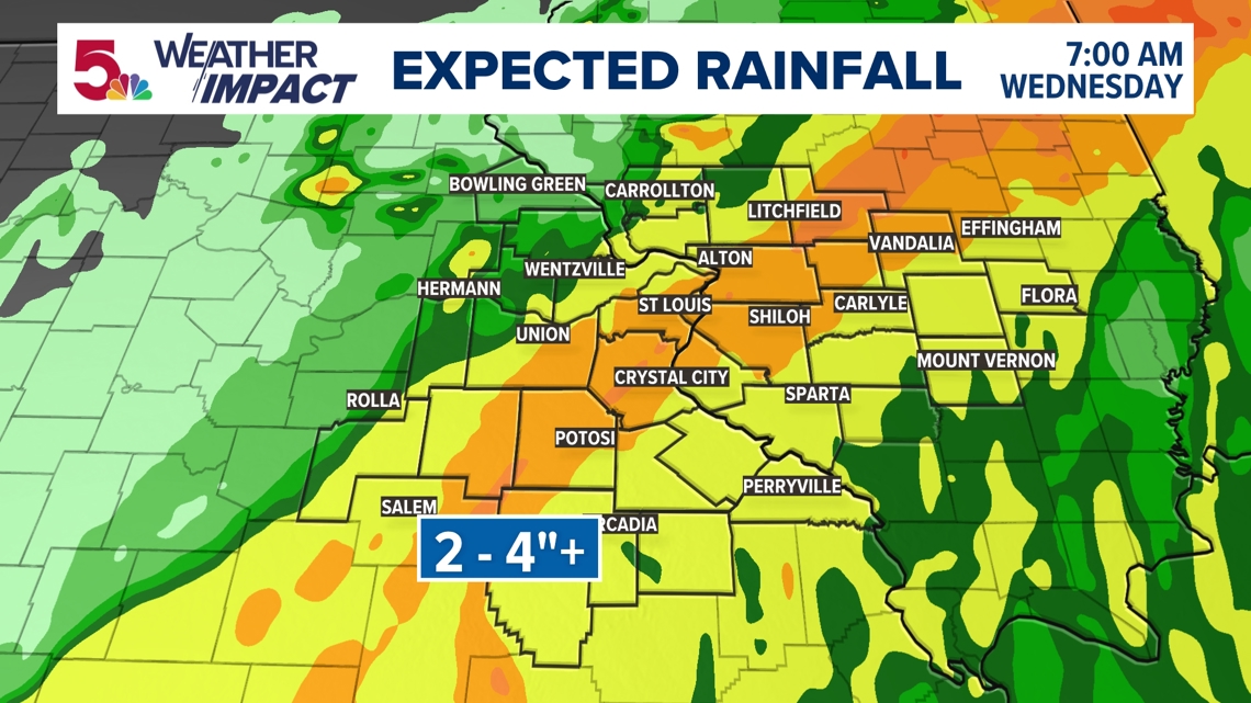
With the storm center tracking near the Missouri Bootheel, a wide swath of two to four inches of rainfall can be expected for many areas of southeast and east central Missouri and southern Illinois. Locally heavier rainfall amounts are expected and will lead to flash flooding in these areas.
This rainfall will also cause rapid rises of tributaries and small streams within the Flood Watch.

By Tuesday night, there will likely be a band of 2" to 4" rainfall through the 5 On Your Side viewing area. This is in addition to the rain that fell during strong thunderstorms Monday afternoon.

Do not drive into water-covered roads!


Rainfall with the very wet ground from our heavy rain over the last week, will add to already swollen rivers. The rain will likely end before sunrise on Wednesday.
Download the free 5 On Your Side app to get the latest watches and warnings and track conditions live with our interactive radar. Use the links below to download now.
5 On Your Side news app
iPhone | Google Play
Monday storms
6:35 p.m. - Main Street reopened in House Springs. High waters trapped a group of adults and children inside Apple of His Eye Daycare on Church Road.
Ashlie Weibley was trying to wait out all this rain at work in House Springs but got caught in traffic backed up for at least half a mile on Main Street around 5:15 p.m. on Monday.
"I pull up and there is just water everywhere and my first instinct is, 'Oh my gosh my babies are in there,'" she told 5 On Your Side's Annie Krall. "There's no way to get in. The water is going way too fast."
All three of her children, ages 1, 6 and 9, were at Apple of His Eye Daycare. First responders said flash flooding caused Bear Creek to rise drastically.
"They were talking about getting search and rescue so then my anxiety gets a little bit higher," Weibley said, adding that three or four other kids along with three adults were trapped.
Blocks away, Valley Middle School also got hit hard by the flash flooding right outside its doors. Thankfully, it was quiet with school being out.
Weibley was relieved things weren't worse for her kids.
"Immediately started praying and got a hold of the day care provider," Weibley said. "She's also the pastor there, started talking to her and she said, 'All the kids are good. Everything is good.' She just told me, 'They're eating hot dogs right now and we're about to go get them.'"
6:30 p.m. - Officials in Jefferson County, Missouri, shared photos of high water in flowing creeks and streams. They reminded people to "turn around, don't drown." Don't try to drive or walk through high water.
6:15 p.m. - Rain continues to the south and east of St. Louis. The rain is lightening up north and west of the metro. A few downpours will continue through 8 p.m. and pick up again Tuesday.
5:39 p.m. - Officials in Washington, Missouri, confirm crews are responding to an Amtrak train incident in unincorporated Franklin County. Officials said one of the wheels of a car came off the track. All cars were upright and no one was injured.
5:30 p.m. - Jefferson County, Missouri - Flash flooding is affecting mobile homes on Indian Springs Road near House Springs. People were being evacuated. At one point Highway 30 in House Springs was down to one lane. There were scattered reports of tree damage and downed power lines.