ST. LOUIS — TAP HERE FOR THE LATEST INFORMATION: Storm Alert: Second wave of storm arrives overnight, will bring heaviest snowfall
The story below is no longer current.
5 On Your Side is in Storm Alert as a winter storm moves through the St. Louis area Wednesday. We're providing live updates on weather and traffic as conditions continue to change throughout the day.
10 p.m.
MetroLink trains will be running with single cars as opposed to the dual-car setup they normally use on Thursday.
the Lambert Airport and UMSL South stations and the Emerson Park and Shiloh-Scott stations in Illinois due to ice accumulation on the overhead lines. Crews are working to fix the issue and passengers are being shuttled by bus and vans between the following stations:
Missouri: Lambert Airport Terminal #1, Lambert Airport Terminal #2, North Hanley, UMSL-North, UMSL-South
Illinois: Emerson Park, JJK Center, Washington Park, Fairview Heights, Memorial Hospital, Swansea, Belleville, College, Shiloh-Scott
For assistance or questions about a particular route, riders should contact Metro Transit Information at 314.207.9786 (text) or 314.231.2345 (call).
All St. Clair County government buildings will be closed Thursday due to the weather.
8 30 p.m.
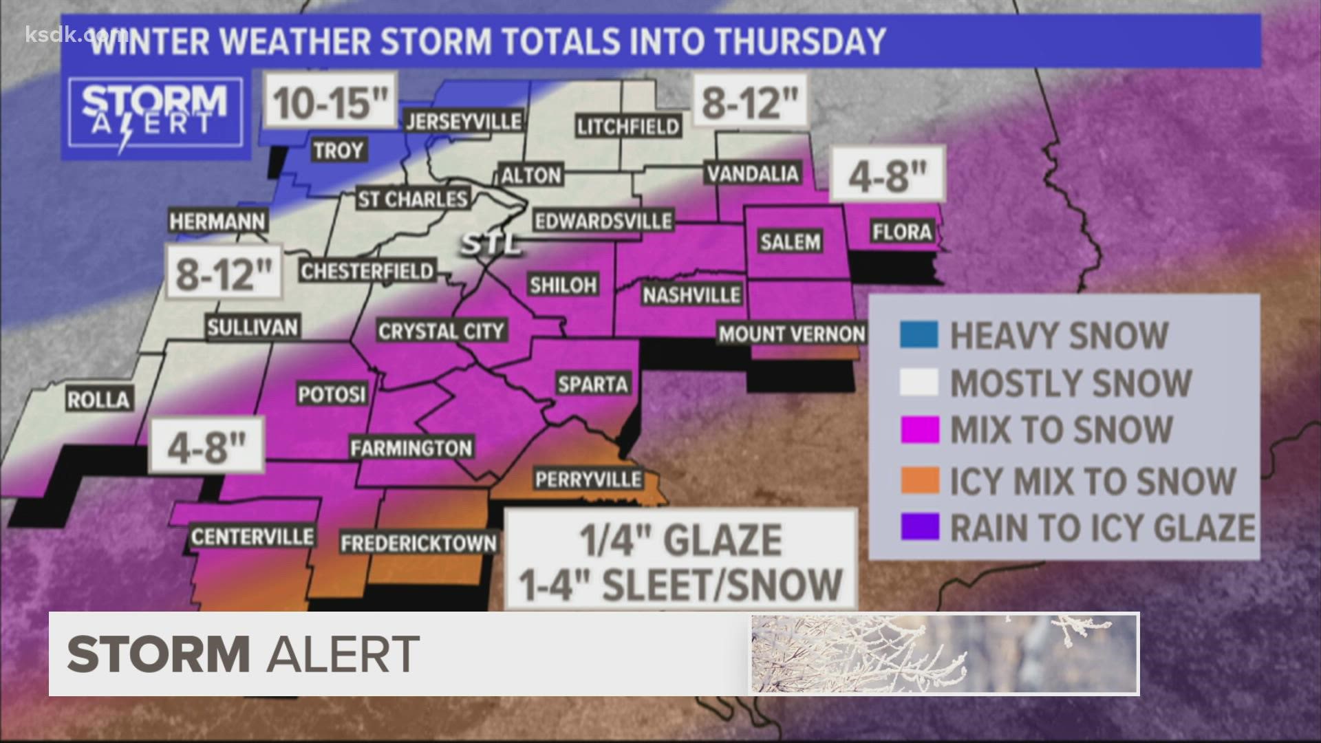
The second wave of the snowstorm is expected to arrive in the St. Louis area late Wednesday and continue through Thursday morning, bringing the heaviest snowfall of the storm.
Most of the St. Louis area will get an additional four to eight inches of snow between midnight and noon. Precipitation in the second wave is expected to be all snow for all but the southernmost portions of the viewing area, where sleet and a wintery mix is likely.
Periods of moderate to heavy snow is expected for much of the area.
6 p.m.
MetroLink trains are unable to operate between the Lambert Airport and UMSL South stations and the Emerson Park and Shiloh-Scott stations in Illinois due to ice accumulation on the overhead lines. Crews are working to fix the issue and passengers are being shuttled by bus and vans between the following stations:
Missouri: Lambert Airport Terminal #1, Lambert Airport Terminal #2, North Hanley, UMSL-North, UMSL-South
Illinois: Emerson Park, JJK Center, Washington Park, Fairview Heights, Memorial Hospital, Swansea, Belleville, College, Shiloh-Scott
MetroBus and Metro Call-a-Ride services are operating on snow routes, and riders should plan for delays due to road conditions and staffing issues.
For assistance or questions about a particular route, riders should contact Metro Transit Information at 314.207.9786 (text) or 314.231.2345 (call).
4:15 p.m.
MoDOT provided an update on road conditions as crews worked to clear the first wave of winter weather across the St. Louis area.
MoDOT officials thanked drivers for staying off the roads unless travel was necessary. Trooper Logan Bolton with the Missouri State Highway Patrol's Troop C said the limited travel resulted in just two crashes that resulted in injuries and no fatal crashes in the St. Louis area. As of 3 p.m., the highway patrol troop responded to 223 calls for service, 130 of which were for stranded drivers and 55 of which were traffic crashes.
"For the most part, our call log hasn't been that overwhelming today," Bolton said, "and I'd like to say that's a correlation with the minimal traffic we've seen out on the roads."
MoDOT officials said crews would use the midday lull in the snow to clear as much of the high-priority roadways as possible before the next wave arrives later Wednesday and into Thursday. They encouraged drivers to continue to stay off the roads as much as possible tonight and tomorrow.
MoDOT District Maintenance Engineer Bob Becker and MoDOT Assistant District Engineer Michelle Forneris would not say how many crews were in the St. Louis area, but said 1,500 trucks were available statewide.
3:15 p.m.
CLOSURES AND CHANGES IN HOURS
Plenty of places around the area are changing their hours or closing altogether as snow continues to fall around the area.
Schnucks and Dierbers are closing their stores early on Wednesday and opening late on Thursday to ensure their employees can make it into work and get home safely. Click the links below to see the locations affected.
Elsewhere in the St. Louis area, the 22nd Judicial Circuit Court was closed on Wednesday and will be closed again on Thursday. The St. Louis Zoo will be closed again Thursday, and a job fair on Friday has been postponed.
St. Louis County announced its government offices and the health department buildings would be closed Thursday. Most St. Louis County parks will also be closed through Thursday due to poor weather conditions. For more information about county parks, follow them on Facebook or Twitter. Residents can also sign up for SMS alerts from the St. Louis County Office of Emergency Management by texting STLCOOEM to 888777.
All O'Fallon, Missouri, city facilities will be closed Thursday. That includes city hall, the municipal court and the senior center. Trash pickup will be bumped one day, meaning Thursday pickups will move to Friday, and Friday pickups will move to Saturday.
St. Peters city facilities will also be closed Thursday, and trash pickup will be delayed. For more information, click here.
The Butterfly House in Chesterfield and Shaw Nature Reserve in Gray Summit will be closed Thursday, February 3.
All three Missouri Historical Society locations — the Missouri History Museum, the MHS Library & Research Center, and Soldiers Memorial Military Museum — will be closed Thursday, as will the St. Louis Art Museum.
1:30 p.m.
Nearly all of the 5 On Your Side coverage area is seeing snow. A few areas are still seeing sleet. There will be a break in the snow before round two arrives later this evening.
Here are some recent snow totals:
- Frankford: 9.5 inches
- Columbia: 6 inches
- Wright City: 4 inches
- Cottleville: 4 inches
- Wentzville: 3 inches
12:30 p.m.
Round one of this winter storm isn't over yet. Snowfall will continue for the next couple of hours until we get a break in the afternoon.
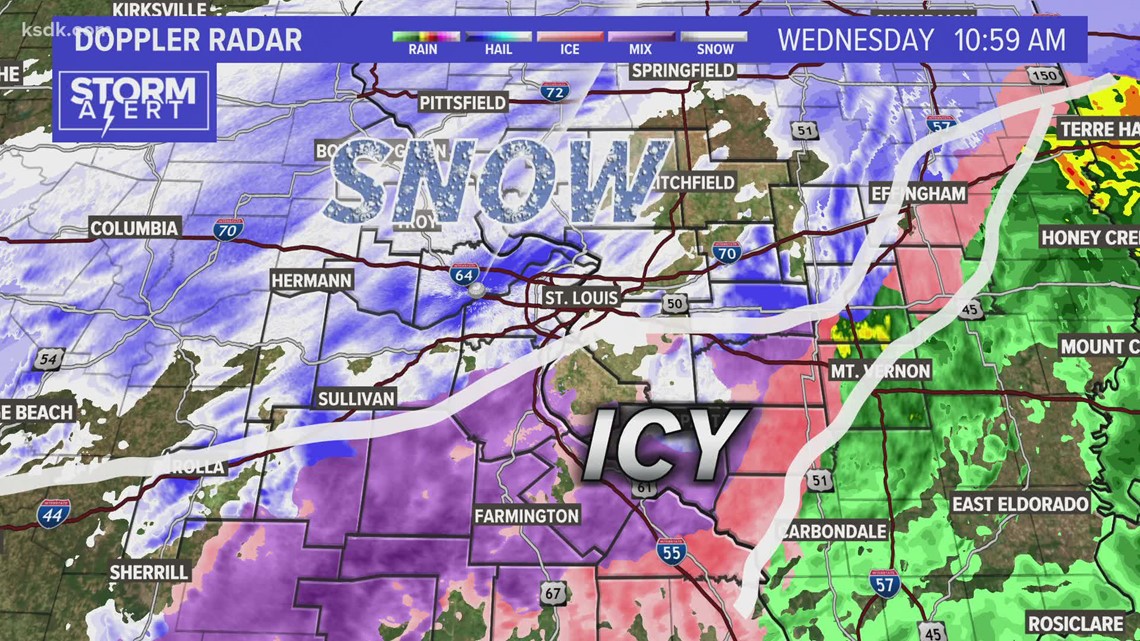
An icy mix of sleet and freezing rain is hitting most areas south of Franklin and Jefferson County and in parts of Illinois.
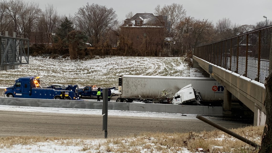
A jackknifed tractor-trailer made a mess on westbound I-70 just east of Mid Rivers Mall Drive, blocking all but the leftmost lanes and spilling about 50 gallons of diesel fuel onto the highway, Central County Fire and Rescue reported. No one was injured.
Alternate routes were advised as MODOT worked to clean up the mess.
11:15 a.m.
Snow and sleet continue to fall over much of the area, while some areas, especially those south of the Interstate 44 corridor, continue to see freezing rain and ice.


The National Weather Service-St. Louis shared a photo of a traffic nightmare underway on Interstate 70 just west of Columbia. The rain-wintry mix changed to snow more quickly in that area, and around five inches of snow has fallen so far.
10:20 a.m.
Data on accumulation is starting to roll in. Here's a look at snow totals so far:
- O'Fallon, Missouri: 3.8 inches
- St Peters: 2.8 inches
- Bridgeton: 2.5 inches
- Carlinville: 2 inches
- Maryville: 2 inches
There are at least a couple more hours of sleet and snow in store for St. Louis. Things should let up around 2 or 3 p.m. before the second round of heavy snow develops tonight. Upwards of 6-12 inches total of snowfall and sleet are predicted for the St. Louis area, with higher amounts to the north and more ice to the south.
St. Louis Lambert International Airport is currently second in the country for the number of canceled flights. According to flight-tracking website FlightAware, Lambert has canceled 151, or 78%, of its outbound flights. For arrivals, 149 have been canceled, or again 78%.
9:15 a.m.
The NWS-St. Louis released a look at road conditions across the area.
According to MoDOT's traveler map, winter precipitation has covered all main highways and interstates on the west side of the Mississippi River.
Michelle Ryan, Director of Emergency Management for St. Louis County, joined County Executive Sam Page's regular Wednesday morning briefing to give an update on the response to the storm.
The office's Emergency Operations Center (EOM) is activated at level 3 -- meaning EOC and OEM staff only. Key staff will provide 24-hour coverage and monitor weather and road conditions, at the ready to assist local first responders if needed.
"My biggest concern during events like this are power outages and the care of our residents should they lose power in these cold temperatures, and stranded motorists," Ryan said.
She urged everyone to stay home if possible and to make sure to pack emergency supplies if they have to go out.
RELATED: Some COVID-19 testing sites in St. Louis area close Wednesday and Thursday for winter storm
8:25 a.m.
Weather conditions that have been in place since around 6:30 a.m. remain with little change.
Mostly sleet and snow continue to fall across the St. Louis metro area. There is accumulation, though the amount that has fallen so far is unclear as snowfall data isn't out just yet.
The Metro East and places south of I-44 continue to see a mix of sleet, snow and freezing rain.
The National Weather Service-St. Louis has released snowfall reports for areas northwest of the viewing area through the 7 a.m. hour. Columbia has seen 4 inches so far, while La Grange and Clarksville further north are reporting 8 inches.
Road conditions remain treacherous with several crashes reported across the region, including a serious crash on I-44 eastbound near Jefferson involving a jack-knifed semi-trailer. There was no word on injuries.


Missouri State Highway Patrol Troop C reported that as of 7:45 it had responded to 17 crashes, 43 stranded motorists and 68 calls for service.
7:10 a.m.
Within the past hour, the sleet-snow mixture has moved into the St. Louis area.
There are more than 700 closures reported in the area, including schools, businesses and government offices. Click here to see a full list of closings.
MetroLink says ice accumulation on overhead lines that power their trains has forced them to halt operations between Lambert and UMSL South stations and 5th & Missouri and Shiloh-Scott stations. Buses are transporting passengers between these stations:
Missouri: Lambert Airport Terminal #1, Lambert Airport Terminal #2, North Hanley, UMSL-North, UMSL-South
Illinois: 5th & Missouri, Emerson Park, JJK Center, Washington Park, Fairview Heights, Memorial Hospital, Swansea, Belleville, College, Shiloh-Scott
6 a.m.
MoDOT gave a 6 a.m. press conference on road conditions as freezing rain changes over to sleet and snow in the metro area. Some traffic incidents have been reported as rush hour begins. MoDOT urged people to stay home if possible. If you have to go out, be careful on the roads, especially over ramps and overpasses.
Temperatures are falling into the low 20s in the west as the cold front pushes through. Far eastern parts of the viewing area remain above freezing but are dropping fast.
The metro area is expected to transition to an all-snow mix within the next couple of hours.
5:20 a.m.
Traffic delays are beginning in western parts of the viewing area and beginning to creep east. MetroLink closed between the Lambert Airport and UMSL South Metrolink stations.
St. Louis Lambert International Airport is reporting at least 90 flight cancellations for Wednesday morning and afternoon.
2 a.m.
Rain changed over to freezing rain and sleet in the St. Louis area by 2 a.m. and snow began to creep in from the northwest.
This story will continue to be updated as weather conditions develop.

