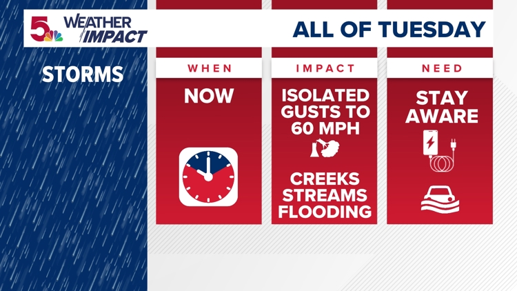
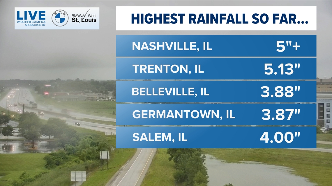
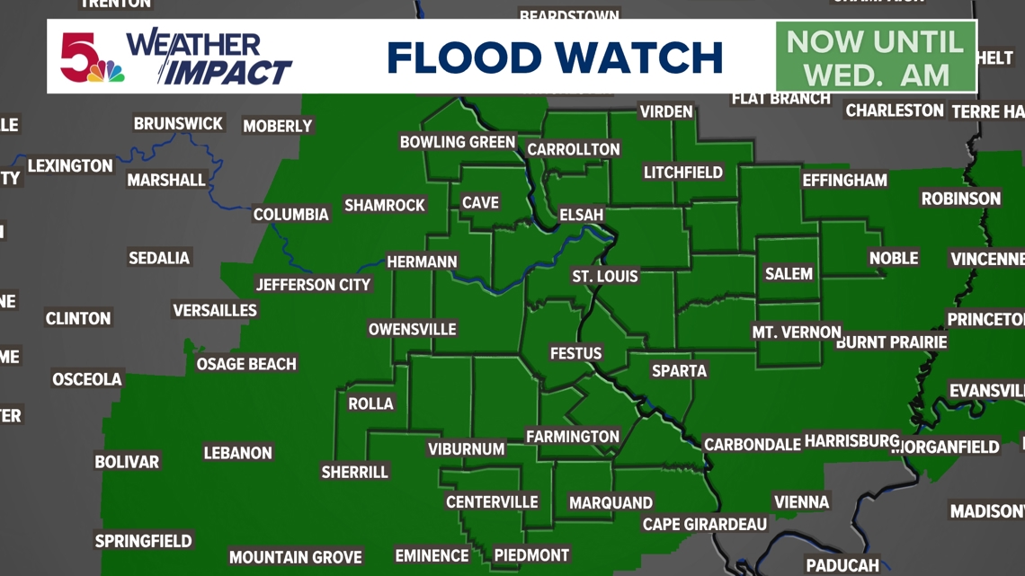
ST. LOUIS — Flooding and flash flooding has been widespread. Rain will taper off this afternoon, but rain and storm chances continue until Wednesday morning. Rain totals have been from 3 to 7" in many areas.
![](https://media.ksdk.com/assets/KSDK/images/ed2c23a6-9469-4084-8a19-b7062074d188/20240716T181409/ed2c23a6-9469-4084-8a19-b7062074d188_16x9.jpg)
![](https://media.ksdk.com/assets/KSDK/images/ed2c23a6-9469-4084-8a19-b7062074d188/20240716T181409/ed2c23a6-9469-4084-8a19-b7062074d188_1140x641.jpg)
![](https://media.ksdk.com/assets/KSDK/images/c196cfdf-400c-4ef1-853d-ddb22f045a2a/20240716T181457/c196cfdf-400c-4ef1-853d-ddb22f045a2a_16x9.jpg)
![](https://media.ksdk.com/assets/KSDK/images/c196cfdf-400c-4ef1-853d-ddb22f045a2a/20240716T181457/c196cfdf-400c-4ef1-853d-ddb22f045a2a_1140x641.jpg)
![](https://media.ksdk.com/assets/KSDK/images/a8322cf2-fb27-44be-a318-9b8a35dd6a4e/20240716T181608/a8322cf2-fb27-44be-a318-9b8a35dd6a4e_16x9.jpg)
![](https://media.ksdk.com/assets/KSDK/images/a8322cf2-fb27-44be-a318-9b8a35dd6a4e/20240716T181608/a8322cf2-fb27-44be-a318-9b8a35dd6a4e_1140x641.jpg)
RELATED: What is a Weather Impact Alert Day?
The worst of the heat is over for a while.
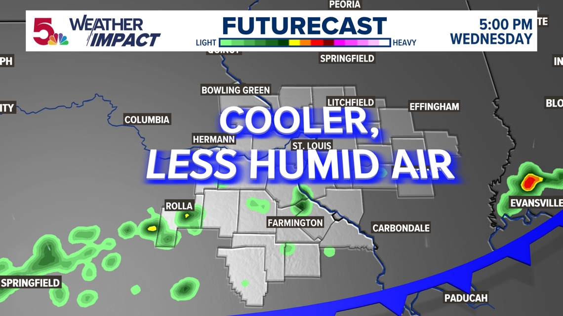
The cold front moves through our area sometime on Wednesday with cooler air and much less humid air later in the day on into Thursday and through the entire weekend. Highs will be in the low 80s with dew points in the 50s to near 60. Enjoy!
![](https://media.ksdk.com/assets/KSDK/images/ce92ebb9-5848-40d6-9e39-1588ea81ceb4/20240715T204133/ce92ebb9-5848-40d6-9e39-1588ea81ceb4_16x9.jpg)
![](https://media.ksdk.com/assets/KSDK/images/ce92ebb9-5848-40d6-9e39-1588ea81ceb4/20240715T204133/ce92ebb9-5848-40d6-9e39-1588ea81ceb4_1140x641.jpg)
For updates watch 5 On Your Side broadcasts or reports 24/7, 5 On Your Side is always streaming on 5+. Download for free on Roku, Amazon Fire TV or the Apple TV app store.